SERDIC TwinVision , web-based XR solution
-
Payment
T/T
-
MOQ
1 ea
-
Supply Ability
9,999,999 ea per One-Time
-
Supply Details
Customization
Negotiable
-
Country of sale
Asia, Middle East, Europe, Americas, World Wide
-
PRICE
-
FOB
USD 30,000.00 ~ 300,000.00
(1 ea)
-
ITEM SPECIFICS
-
Brand
Model TwinVisionSERDIC
-
origin
Republic of Korea
-
Size(Capacity)
-
-
Style
web-based XR solution
-
Gender
All
-
age-appropriate
All
PRODUCT DESCRIPTION
TwinVision
Service Overview
1. A web-based XR solution that visualizes both underground infrastructure (pipes, conduits, etc.) and architectural structures in 3D using CAD drawings or paper plans.
2. Supports real-time, on-site visualization and interaction via smartphones or tablets—enabling accurate site assessment, intuitive editing, and seamless communication between field personnel and managers.
2. Supports real-time, on-site visualization and interaction via smartphones or tablets—enabling accurate site assessment, intuitive editing, and seamless communication between field personnel and managers.
Key features
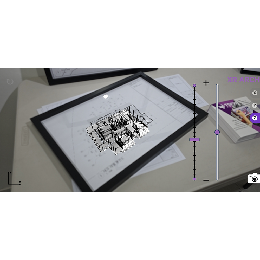
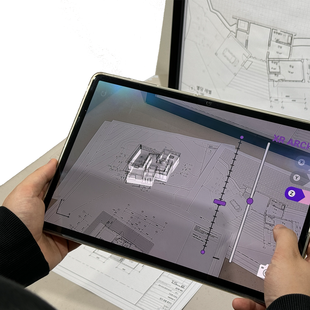
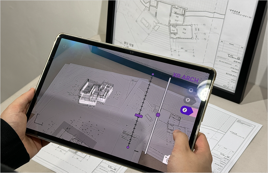
XR Arch
1. Aligns 3D architectural models on top of physical paper plans using smartphone or tablet cameras, providing real-time spatial visualization.
2. Supports transparency adjustment, material rendering, and sectional views (X, Y, Z axes) for structural understanding.
3. Enables sketching, note-taking, and photo capture on paper drawings using mobile devices.
4. Enhances collaboration by allowing designers and field workers to review and discuss design intent through visual overlays.
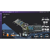
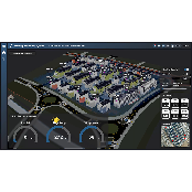
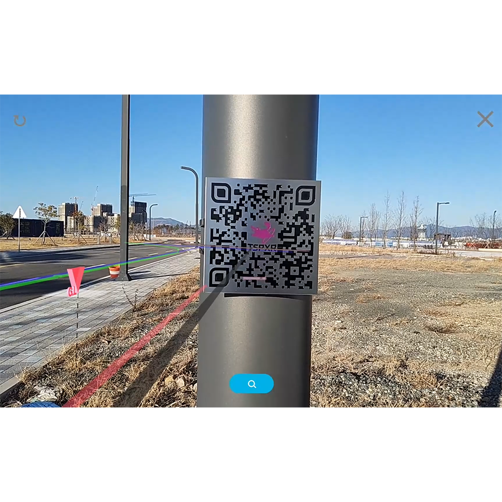
XR Underground
1. Converts underground infrastructure drawings into 3D models viewable through AR on-site using only a smartphone.
2. Supports a variety of file formats (GeoJSON, DXF, SHP, KML, DWG, etc.) and allows CAD drawing updates via a web-based authoring tool.
3. Enables x-layer selection, editing, and automatic report generation during field work.
4. Allows real-time updates of construction history, maintenance records, and equipment data.
5. Supports 3D merging of new and pre-modeled infrastructure for accurate, up-to-date visualization.
Advantages
1. Universal Compatibility:
Uses a proprietary Visual-SLAM engine optimized for web and mobile, with no need for app installation or specific hardware—just a smartphone camera.
2. Fully Web-Based:
All processes, from data upload to visualization, are performed through the browser, supporting integration with existing digital twin systems.
3. Real-Time Editing & Updates:
Any modifications made in the field are reflected immediately, reducing time lag and ensuring data consistency.
4. Cost-Effective and Scalable:
Eliminates the need for expensive HMDs or local applications, and is ideal for both skilled and unskilled workers.
5. Authoring Tool Provided:
Allows users to create and update content directly, empowering field teams and managers to manage data independently.
How to Use
1. Power on the device and connect to the communication network.
2. Access the dashboard via a browser or monitoring platform.
3. View live video feeds and sensor data, including x-alerts for detected hazards.
4. Submit reports with images or video clips directly from the field.
5. Analyze AI inference results and 3D reconstructions of incidents via the control platform.
6. Monitor worker biometrics and receive automatic x-alerts for abnormal conditions.
FAQ
Q1. Do I need to install a separate app to use the system?
A1. No, the platform runs entirely in a web browser and requires no installation.
A1. No, the platform runs entirely in a web browser and requires no installation.
Q2. Can I use it on any smartphone or operating system?
A2. Yes, the Visual-SLAM engine is device-agnostic and works on most smartphones with a standard camera.
Q3. What file formats are supported?
A3. The platform supports GeoJSON, DXF, SHP, KML, DWG, JPG, PDF, and other GIS/CAD formats.
Q4. Can I overlay 3D models on real-world locations or paper plans?
A4. Yes, XR Underground supports site-based AR mapping, and XR Arch allows 3D alignment with printed plans.
Q5. Is real-time editing supported?
A5. Yes, edits made in the field are saved instantly and synced to the main system.
Company Overview
SERDIC is an innovative startup developing a web-based Digital Twin platform, AI agents, and simulation technologies to enable efficient digital transformation across industrial sites.
With a focus on simplifying and accelerating industrial digitalization, SERDIC offers a modular suite of transformation solutions tailored for seamless integration. By combining AIoT with data-driven AI technologies, the platform delivers real-time monitoring, anomaly detection, predictive maintenance, and simulation-based visualization — all within a single, web-accessible Digital Twin environment.
With a focus on simplifying and accelerating industrial digitalization, SERDIC offers a modular suite of transformation solutions tailored for seamless integration. By combining AIoT with data-driven AI technologies, the platform delivers real-time monitoring, anomaly detection, predictive maintenance, and simulation-based visualization — all within a single, web-accessible Digital Twin environment.
PAYMENTS DETAILS
This supplier supports payments for offline orders
- Telegraphic Transfer : T/T
- Name : Jinkyu Kang
SHIPPING
Shipping from :
Republic of Korea
- 23 Seokgye-ro 18-gil, Nowon-gu, Seoul (01886)
SERDIC Inc.
The person in charge
Jinkyu KangAddress
23 Seokgye-ro 18-gil, Nowon-gu, Seoul (01886)
Introduction
SERDIC is an innovative startup developing a web-based Digital Twin platform, AI agents, and simulation technologies to enable efficient digital transformation across industrial sites.
With a focus on simplifying and accelerating industrial digitalization, SERDIC offers a modular suite of transformation solutions tailored for seamless integration. By combining AIoT with data-driven AI technologies, the platform delivers real-time monitoring, anomaly detection, predictive maintenance, and simulation-based visualization — all within a single, web-accessible Digital Twin environment.
-
- Business Type :
- Knowledge Service
-
- Main Product :
- Web-Based Digital Twin Platform and AI Solutions
-
- Established :
- 2021-05-24
-
- Total Annual Revenue :
- 3~5 million (KRW)
-
- Total Employees :
- 5~10 people
COMPANY ENVIRONMENT

Please suggest a variety of your ideas such as design, impact, enhancements, etc
Captcha Required
Please enter the text on the left image to prevent automatic input.
0 / 4000
질문이 없습니다.
CUSTOMER REVIEWS (0)

TRADE EXPERIENCE
-
- Total revenue
- 3~5 million (KRW)
-
- Total export revenue (previous year in USD)
-
- Number of foreign trade employees
- 5~10 people
COMPARISON TO SIMILAR ITEMS more
- No Items
- supplier level
- MEMBER
- SERDIC Inc. Seller's Store
- Seller's Store url
- Response Level
★ ★ ★ ★ ★

- Supplier Level
★ ★ ★ ★ ★
- Transaction Level
★ ★ ★ ★ ★
SUPPLIER BEST